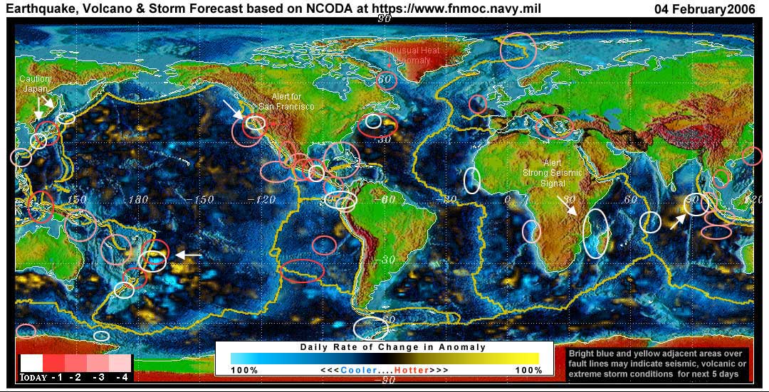
Expected Earthquake, Volcanic or Storm Activity for the Next 1 to 5 Days
Are YOU Prepared?
HOLLY NOTE: In light of Stan's NCODA map today and yesterday, we found this prophecy most interesting. It was posted today by Dimitru Duduman's grandson, Michael Boldea. This is his first prophetic dream in almost a year and was confirmed by two others who experienced the identical dream that same night. It bears reading.
February 4, 2006
By Stan Deyo
Home https://standeyo.com
WARNING: USA
San Francisco is still hot spot of today's forecast. The signal between Mendocino and San Francisco along the San Andreas Fault has moved inland a bit and has oriented along the San Andreas. There have already been two small temblors in the San Francisco area since our forecast yesterday. People in the immediate area of this location should still prepare to leave their homes should a major quake strike SF in the next 4 days.... possibly even tonight.
Also a second thermal anomaly has again appeared off the NE US coastline just south of Nova Scotia and possibly vectoring into Massachusetts to Virginia coastal region.
Caution: Japan
Both Hokkaido and Fukuoka show medium strength signals and may shallow depth.
Caution: Southwest Ring of Fire
From Western Samoa down to the North Island of New Zealand is still at risk of several large seismic events for the next 5 days or more. Watch the White Island volcano in North Island for activity. It is the trigger for Ruapehu, Taupo and other volcanoes on North Island.
Caution: Madagascar and India
A strong seismic signal has appeared running from the SE coast of Africa diagonally SSE through Madagascar along a large rift line. If this converts to a quake it could generate a tsunami directed toward India's west coast and the island of Sri Lanka within 4 to 5 hours of the major release.
Sumatra:
West of the NIAS Richter 9.2 quake of 24 Dec 2004 and along a north south ridge in the Ocean a medium strength signal is showing. It might generate a tsunami if it converts but I don't think it is highly probable. However, if the animals in the region indicate otherwise, take proper precautions.
ADVICE:
If you live in the areas under Caution or Warning, have your emergency supplies in order and make sure you have a clear and unobstructed path out of your home should a seismic event occur while you are sleeping. Keep warm clothing, flashlight, water and food in a back pack to grab and move outside away from collapsing structures.
Summary:
The surface of the planet is under stress today - more so than yesterday. —Stan Deyo
For an explanation of how these maps are produced, please see this area.
Stan's analysis shows areas of possible earthquake or volcanic activity, or extreme storm conditions for the next 1 to 5 days. Pay particular attention to areas marked by white circles. The continuous yellow line denotes plate tectonic boundaries as well as the Ring of Fire. Go to the raw data map where it is easier to see the areas of concern. Go to Stan's earthquake map archives.
NEW FEATURE: The circles in varying shades of red are quake prediction zones Stan made from 1 to 4 days ago - with dark red being 1 day ago and the lightest red being 4 days ago. White circles are Stan's prediction zones for today. Tomorrow these white circles will become dark red and will get lighter as each day passes until they are removed.
These circles indicate the stresses in an area and warn of a probable quake in an area. The areas do not always convert to a quake. When a quake does occur and has been in or fairly close to the outer radius of a circle I have drawn over a given fault zone area then it is counted as a "hit". When stress signals go into a large land mass I have to estimate the radius of the circle and the vector to the nearest major fault on the land mass.
DEYO NOTES: For earthquake maps, see the USGS "shake maps" (click anywhere on the global map for a closer view). For quakes USGS may not list, go to the European-Mediterranean Seismological Center's map and scroll to the bottom of the page for a global view. You can compare these maps for the next 5 days to Stan's NCODA maps, to see the hits of his seismic target zones (white circles).
Earthquake lists can viewed at EMCS and at USGS.
Ecuador's Geophysics Institute at the National Polytechnic School, does not list quakes on a daily basis as does the USGS and other entities, but when there are significant events, they post them in PDFs.
Disclaimer: Some of the forecast stress areas can be in error up to 30% due to cloud cover variations and false signals from buoys.